Cincinnati Subway
Unfinished subway system in Ohio
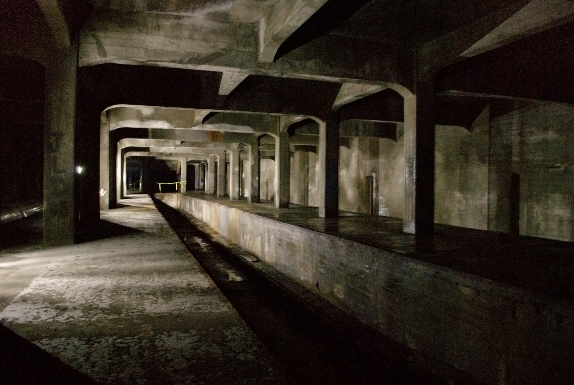
The Cincinnati Subway is a partially completed rapid transit system beneath the streets of Cincinnati, Ohio. Although the system only grew to a little more than 2 miles (3.2 km) in length, its derelict tunnels and stations make up the largest abandoned subway tunnel system in the United States. Construction began in the early 1900s as an upgrade to the Cincinnati streetcar system, but was abandoned due to escalating costs, the collapse of funding amidst political bickering, auto industry lobbying against public transit projects, and the Great Depression during the 1920s and 1930s.
In 1928, the construction of the subway system in Cincinnati was indefinitely canceled, and there are no plans to revive the project. Numerous efforts and proposals have been made since the 1930s to repurpose the existing tunnels for transportation projects, infrastructure, storage facilities, and commercial or community hubs.
History
Rapid transit was seen as the solution for downtown congestion in Cincinnati during the first quarter of the 20th century. Six million dollars were allocated for the project, but construction was delayed due to World War I. Unexpected post-war inflation doubled the cost of construction, so the project could not be finished at the original estimated price.
Various attempts to use the tunnels for mass transit have been unsuccessful. Political squabbling, the Great Depression, World War II, automaker lobbying and negative news media publicity have contributed to the failure of the proposals. Today, many Cincinnatians are unaware of the tunnels beneath them.
Context
From 1825 to 1920 the Miami and Erie Canal divided Cincinnati's residential neighborhood of Over-the-Rhine from the business district of downtown. The canal was used to transport goods and people from the Great Lakes to the Ohio River and subsequently the Mississippi River via Cincinnati, until the popularity of railroads caused it to become disused. The canal then became very polluted due to people dumping trash in it and using it as a sewer. The canal became unprofitable by 1856 and was abandoned by the city in 1877.
On September 15, 1883, a weekly Cincinnati magazine called The Graphic proposed that the "dead old ditch" be used to provide an unobstructed route for a subway system, with a large boulevard above.
Cincinnati began adopting electric streetcars in 1888; this soon became the main form of public transportation. During this period Cincinnati was one of the seven most populous US cities and had a rate of growth and economic importance that was similar to that of New York City and Chicago. The slow streetcars shared the crowded streets with horse-drawn carriages and people, and collided with the first automobiles on an almost daily basis. It was not unusual for trips between downtown and the surrounding suburbs to take 45 minutes to an hour. Despite having 222 miles (357 km) of streetcar tracks, the city found itself in a growing traffic nightmare.
Another newspaper, the Cincinnati Commercial Tribune, gave encouraging words to the public and said "We believe that the city we love, our home, is at the turning point, and that with the coming of Rapid Transit we will have the beginning of a Greater, More Prosperous, Healthier and Happier Cincinnati. We believe that a Vote for the Loop is a Vote for the best interests of all of us, and it is with pride that we state that every newspaper in the city is for the Loop, and practically all of the Business organizations as well as the Trades Unions." This helped the project win the fight in the polls when the people of Cincinnati enthusiastically passed bill to start construction.
Planning
In 1910, Henry Thomas Hunt spearheaded plans for a new rapid transit system. The next year, City Council convinced the Ohio State Legislature to lease the city's portion of the canal for use as a boulevard and subway system. The city hired experts who had worked on Boston's and Chicago's rapid transit systems to research the best possible implementation for Cincinnati's rapid transit system. The result were four "Schemes", or proposed routes. The chosen plan—Scheme IV, modification H—looped around the city hitting the central suburbs of St. Bernard and Norwood, the eastern suburbs of Oakley and Hyde Park, and then returned into downtown.
In 1916, City Council authorized a bond issue of $6 million with an interest rate of 4.25 percent, and then held a plebiscite on the rapid transit plan. The bond was supposed to fund a 16 miles (26 km) subway system stretching across Cincinnati, which would, in turn, slow or even stop the decline of Cincinnati's population at the time. One advertisement in support of the subway proclaimed, "Every newspaper in the city is for the Loop, and practically all of the Business organizations as well as the Trades Unions." On April 17, 1917, Cincinnati citizens voted in favor of using the bond for a Rapid Transit system, 30,165 to 14,286. The system would be built as a below grade, at grade and elevated railway, with the Underground portion to be built in the Miami and Erie Canal bed through downtown, and then extend through the Mill Creek valley to St. Bernard, Norwood, Oakley.
Proposed route: description from 1916 bond campaign
- Follows canal bed from Walnut Street to Carthage Pike.
- Exceptions – Marshall Avenue, Bates Avenue and bend south of Ludlow Avenue, for the purpose of eliminating curves in canal bed that are so sharp as to be impossible to operate at high speed.
- Subway: Fourth and Walnut Street to Brighton.
- Open subway: Brighton to Bates Avenue.
- Open cut or fill: Bates Avenue to Crawford Station.
- Necessary covered section for approaches to Boulevard.
- Sassafras Street.
- Brashers Street.
- Ludlow Avenue.
- Necessary covered section for approaches to Boulevard.
- Open surface line in canal bed: Crawford Station to Carthage Pike, except at Mitchell Avenue, where it leaves canal bed and comes level to Mitchell Avenue.
- Street surface Line: Carthage Pike, Tennessee Avenue, Maple Avenue, Smith Road.
- Open cut or fill along Duck Creek Road on privet right of way: Oakley Station to Lake Avenue ravine (a short distance west of Potomac Avenue).
- Open cut or fill in Lake Avenue ravine from Lake Avenue ravine to Owls Nest Park.
- Subway under Owl's Nest Park and Madison Road.
- Tunnel under Beechwood Subdivision (Wurlitzer Property).
- Concrete trestle along Ohio River bluff to Eden Park Reservoir.
- Steel elevated on Third, Martin, Pearl and Walnut Streets.
- Passes from elevated to subway between Third and Fourth Street on Walnut Street.
- Rapid Transit with no grade crossing from Oakley Station to Crawford Station by the way of downtown district.
- High speed surface line from Crawford Station to Oakley Station on north side.
Proposed stations-Scheme Four: Description from 1916 bond campaign
- Oakley Station; at junction of smith Road and Duck Creek Road.
- Dana Station; near intersection of Dana and Duck Creek Road.
- Madison Station; at Madison Road, opposite Owl's Nest Park.
- Butler Station; on Pearl Street, at Pennsylvania R. R. Station.
- Fountain Square Station; under Walnut Street at Fountain Square.
- Ninth Street Station; under Walnut Street, Between Eight and Ninth Street.
- Canal Station; Canal Street, between Elm and Vine Street.
- Liberty Station; in Canal bed, at Liberty Street.
- Brighton Station; in Canal bed, at Crosstown Bridge.
- Hopple Station; at the intersection of the Canal and Hopple Street.
- Ludlow Station; at the south end of the Ludlow Avenue Viaduct.
- Crawford Station; in the Canal Right of Way, opposite Spring Grove Cemetery.
However, because the United States entered World War I just 11 days earlier, construction was halted because no capital issues of bonds were permitted during the war.
War conditions have prompted the opinion in certain official quarters that it would be unwise to proceed with the construction of the loop until after the war. High costs of materials and the difficulty in obtaining deliveries are cited as arguments in favor of the temporary abandonment of the project.
Content sourced from Wikipedia under CC BY-SA 4.0